The latest update from Jamaica’s National Meteorological Service was issued in Bulletin Number 21, released at 8:00 a.m. on Monday.
See below:
The Meteorological Service has maintained a HURRICANE WARNING for Jamaica, as dangerous Hurricane Matthew continues to move northward towards Jamaica.
The following dangerous effects of a hurricane are expected to affect Jamaica by Monday:
• Dangerously high water or a combination of dangerously high water and exceptionally high waves, even though winds expected may be less than hurricane force;
• Average wind speeds greater than 118 kilometres per hour;
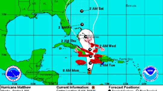
At 7:00 a.m. the centre of Hurricane Matthew was located near Latitude 15.4 degrees North, Longitude 74.9 degrees West. This is about 355 kilometres (220 miles) southeast of Kingston, Jamaica or 450 kilometres (280 miles) southwest of Port au Prince, Haiti.
Matthew is moving toward the north near 9 km/h (6 mph) and a general northward motion with some increase in forward speed is expected through Tuesday. On the forecast track, the centre of Matthew will approach Jamaica and southwestern Haiti tonight, and eastern Cuba on Tuesday.
Maximum sustained winds are near 215 km/h (130 mph), with higher gusts; however, Matthew remains a Category 4 hurricane. Some fluctuations in intensity are possible during the next couple of days, but Matthew is expected to remain a powerful hurricane through Tuesday.
Hurricane-force winds extend outward up to 45 km (30 miles) from the centre and tropical storm-force winds extend outward up to 315 km (195 miles).
RAINFALL:
Outbreaks of heavy showers and thunderstorms are expected to continue today and into Tuesday, as Hurricane Matthew approaches Jamaica. Matthew is expected to produce excessive rainfall especially over eastern parishes, with the greatest accumulations likely over higher elevations of Portland, St. Thomas and St. Andrew. These rainfall amounts can produce extensive flooding and trigger dangerous landslides.
WIND:
Wind direction across the island is expected to be generally out of the northeast as Hurricane Matthew approaches. St. Mary, Portland, St. Thomas, Kingston, St. Andrew and St. Catherine should experience gusty winds at first, with these becoming sustained at gale force as Matthew moves closer to Jamaica’s eastern-most point. Wind speeds are also expected to be stronger over higher elevations, with Tropical Storm conditions expected later today and tonight over these parishes.
STORM SURGE:
Storm surges of 2-3 meters (6-10 ft) are expected over coastal areas of northeastern and southeastern parishes as Hurricane Matthew takes a path between Jamaica and Haiti. All small craft operators are further advised to remain in safe harbour until all warning messages have been lifted and wind and sea conditions return to normal.
The Meteorological Service continues to monitor the progress of this system and all interests are reminded to pay special attention to further Releases.
The next Bulletin on Hurricane Matthew will be issued at 11:00 a.m. today.