


Tropical Storm Maria has been upgraded to hurricane status, and is forecast to become a near major hurricane with strengthening expected over the next 48 hours.
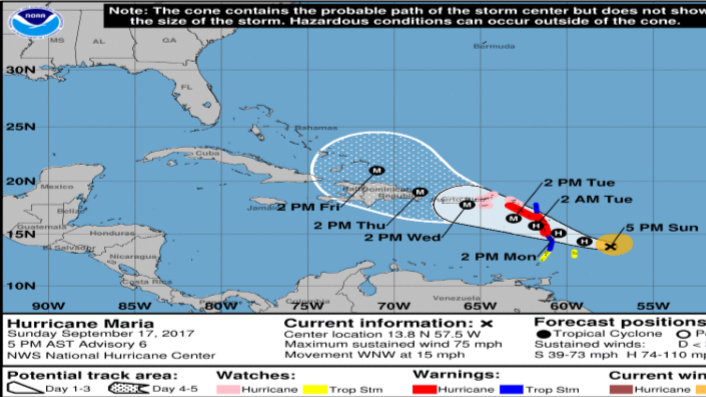
According to the Trinidad and Tobago Meteorological Service (Met Office) as of 5 pm today Hurricane Maria was centered near 13.8N latitude and 57.5W longitude, which is approximately 445 km east-southeast (ESE) of Dominica or 225 km east-northeast (ENE) of Barbados.
The hurricane is moving in a west-northwesterly direction at approximately 24 km/h.
A slower west-northwest motion is expected during the next few days with maximum sustained winds having increased to 120 km/h with higher gusts.
The T&T Met Office said additional strengthening is expected during the next 48 hours and Maria is forecast to become a near major hurricane when it moves across the Leeward Islands on Monday night.
Hurricane Warnings are in effect for Dominica, Guadeloupe, St. Kitts, Nevis and Montserrat.
A Hurricane Watch is in effect for the U.S. Virgin Islands, British Virgin Islands, Saba and St. Eustatius, St. Maarten, St. Martin and St. Barthelemy, and Anguilla.
A Tropical Storm Warning is in effect for Martinique, Antigua and Barbuda, Saba and St. Eustatius and St. Lucia.
Tropical Storm Watches are in effect for Barbados and St. Vincent and the Grenadines.
A Hurricane Warning means that hurricane conditions are expected somewhere within the warning area and is issued 36 hours before the first occurrence of tropical-storm-force winds, conditions that make outside preparations difficult or dangerous.
A Hurricane Watch means that hurricane conditions are possible within the watch area. A watch is typically issued 48 hours before the anticipated first occurrence of tropical-storm-force winds, conditions that make outside preparations difficult or dangerous.
A Tropical Storm Warning means that tropical storm conditions are expected somewhere within the warning area within 36 hours.
A Tropical Storm Watch means that tropical storm conditions are possible within the watch area, generally within 48 hours. This system can trigger moderate to heavy rainfall on Sunday night and into Monday across the Windward Islands, and from Monday morning in Trinidad and Tobago.
The Met Office said it is closely monitoring the progress of this system and advised those with interests in the Lesser Antilles to pay close attention to information being issued.
Trinidad and Tobago is not under any tropical cyclone threat, watch or warning.
Another bulletin will be issued at 6 am tomorrow, or sooner, if the situation warrants.