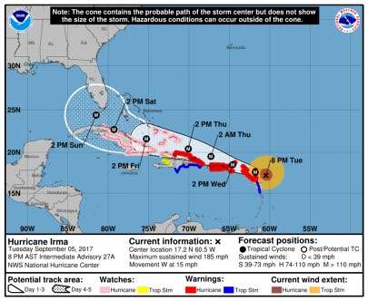
HURRICANE Irma, wielding the most powerful winds ever recorded for a storm in the Atlantic Ocean, was last night bearing down on the Leeward Islands of the north-east Caribbean on a forecast path that could take it toward Florida, United States, over the weekend.

The hurricane is not a threat to Jamaica, but the country’s Office of Disaster Preparedness and Emergency Management (ODPEM) said yesterday that as the system moves closer to the island on Friday/Saturday, it is expected to influence weather conditions, producing rainfall of varying intensity.
The ODPEM said minister with responsibility for disaster risk management Desmond McKenzie — the minister of local government and community development — was briefed yesterday morning by director of the Meteorological Service of Jamaica, Evan Thompson, and the director general of the ODPEM, Major Clive Davis, who asked Jamaicans to continue monitoring the media for further information pertaining to Hurricane Irma and take the necessary precautions.
Irma, a dangerous Category Five hurricane, posed an immediate threat to the small islands of the northern Leewards, including St Kitts-Nevis, Antigua and Barbuda, as well as the British and US Virgin Islands and Puerto Rico.
“The Leeward Islands are going to get destroyed,” warned Colorado State University meteorology professor Phil Klotzbach, a noted hurricane expert. “I just pray that this thing wobbles and misses them. This is a serious storm.”
Irma had maximum sustained winds of 185 mph (295 kph) in late afternoon as it approached the Caribbean from the east, according to the US National Hurricane Center in Miami.
Four other storms have had winds that strong in the overall Atlantic region, but they were in the Caribbean Sea or the Gulf of Mexico, which are usually home to warmer waters that fuel cyclones. Hurricane Allen hit 190 mph in 1980, while 2005’s Wilma, 1988’s Gilbert and a 1935 great Florida Key storm all had 185 mph winds.
Irma is so strong because of the unusually warm waters for that part of the Atlantic.
Hurricane-force winds extended outward up to 60 miles (95 kilometres) from the centre and tropical storm-force winds extended outward up to 175 miles (280 kilometres).
The centre of Irma was about 130 miles (210 kilometres) east of Antigua and about 135 miles (220 kilometres) east-southeast of Barbuda, prompting an ominous warning from officials as the airport closed.
People in the two-island nation should seek protection from Irma’s “onslaught”, officials warned in a statement, closing with: “May God protect us all.”
Several small islands were directly in the path of the storm. In addition to Barbuda they included Anguilla, a small, low-lying British island territory of about 15,000 people.
Authorities there converted three churches and a school into shelters as they prepared for a big storm surge and the full brunt of the winds.
“People normally go to friends and family during a storm. We’ll see,” said Melissa Meade, director of the Disaster Management Department. “We’ll find out soon enough.”
The storm was moving west at 15 mph (24 kph), and the hurricane centre said there was a growing possibility its effects could be felt in Florida later this week and over the weekend.
If it stays on the forecast track and reaches the Florida Straits, the water there is warm enough that the already “intense” storm could become much worse with wind speeds potentially reaching 225 mph, warned Kerry Emanuel, an MIT meteorology professor.
Governments and disaster officials in the Leeward Islands pleaded yesterday with residents to take the necessary precautions to safeguard lives as the powerful hurricane gets ready to unleash its fury on the chain of islands.
“In light of the fact that the pending hurricane has been categorised as being extremely dangerous, the security forces have advised that the public should be foremost concerned about their safety and well-being, and therefore should refrain from being on the streets after 6:00 pm,” St Kitts-Nevis Prime Minister Dr Timothy Harris said in a radio and television broadcast.
“Only essential workers are expected to be outdoors and on the streets. Moreover, we seriously advise, for their own safety and security, that our citizens and residents remain indoors and continue to listen to all official advisories on the hurricane. The official government agencies will indicate when it is safe to venture outdoors after the passage of the hurricane.
Similar warnings were been given by the governments of Antigua and Barbuda, Anguilla and Montserrat as the hurricane is accompanied by life-threatening wind, storm surge, and rainfall.
Several shelters have been opened to accommodate people and many people were seen bordering up their property as the storm inched closer to the islands.
Last night, the Barbados-based Caribbean Disaster Emergency Management Agency (CDEMA) said it has activated the regional coordinated plan and that the regional response teams — including the Caricom Disaster and Assessment Coordination, the Caricom Operations Support Team, and the Regional Security System, as well as the Caricom Disaster Relief Unit have been placed on standby.
“The CDEMA is preparing the operational plan with potential scenarios and pre-impact analysis of vulnerable areas in the threatened states. CDEMA is equipped to offer support through the mobilisation and deployment surge capacity in specialised technical areas to its participating states and stands ready to respond as required,” the agency said.
Meanwhile, as Hurricane Irma bore down on the Caribbean yesterday, Tropical Storm Jose emerged in the Atlantic Ocean to the east of Irma, the National Hurricane Center said.